84 County Road 2900, Aztec, New Mexico 87410
Check for current hours here
Constructed by the Pueblo Indians in the Four Corners area of the state sometime in the 12th or 13th century, this monument served as part of the Pueblo people's migration journey, and today lies on the state’s Trail of the Ancients Scenic Byway.
Visitors can explore the 900-year old ancestral Pueblo Great House – which boasts over 400 masonry rooms – and see not only the original timbers holding up the roof, but the fingerprints of the ancient workers in the mortar.
The trail walk through the Ruins is only half a mile, and the impressive Great Kiva, a 40-foot diameter semi-subterranean structure which served as the central religious site of the complex, is now the largest reconstructed kiva in the country.
15 Entrance Rd, Los Alamos, New Mexico 87544
Check for current hours here
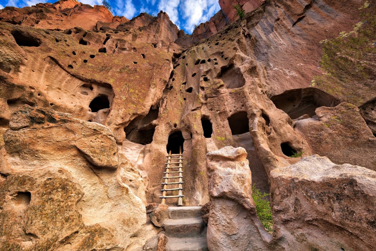
Bandelier National Monument protects over 33,000 acres of rugged canyons and high, open mesas, and most of the pueblo structures here date to two time periods (1150 and 1600 AD). The Ancestral Pueblo peoples who called this place home from about 1150 AD to 1550 AD and created a community by carving out the volcanic tuff (igneous rock formed from volcanic eruptions) and maintaining a field of crops on the mesa that topped off their mountainside domiciles.
By 1550, though, these Ancestral Puebloans had to move—forced off the mesa by drought and other difficulties. Their sudden exodus has troubled many an anthropologist (most of whom lay the blame on overharvesting the land, or on too long a drought), but the Puebloans’ oral traditions, at the least, explain where their descendants ended up: largely on pueblos along the Rio Grande (Cochiti, San Felipe, San Ildefonso, Santa Clara, Santo Domingo).
Most visitors explore Bandelier by foot—taking one of several available hiking trails. The Main Loop Trail is the quickest and easiest. It’s a 1.2 mile loop trail that starts at the Visitor Center and leads through excavated archeological sites in Frijoles Canyon. (A portion of this trail is handicapped accessible.) The three-mile round-trip Falls Trail leads downcanyon from the Visitor Center to the scenic Upper Falls. The Tsankawi section of the park, 12 miles from the main section, offers a 1.5 mile mesa-top walk. Take in views of the excavated cliff dwelling spaces that were cut into the rock, the petroglyphs, the large unexcavated Ancestral Pueblo village, and wide open vistas. This trail includes four ladders (optional to climb).
For longer hikes, the Bandelier backcountry offers opportunities for all-day or even multiple-day overnight backpacking trips. Most of the 70 miles of trails are in the officially designated Bandelier Wilderness. Free permits, required for overnight trips, can be obtained in person at the Visitor Center.
The Visitor Center area includes a museum, bookstore, 14-minute movie, and information, with the gift shop, snack bar, and picnic area nearby. During the busy season most visitors must take a free shuttle bus from White Rock. Pets only allowed in the parking area and campground.
Pecos National Historical Park P.O. Box 418, Pecos, New Mexico 87552
Check for current hours here
Commonly referred to as the “Gettysburg of the West,” the Battle of Glorieta Pass was the Civil War site where Union soldiers not only put an end to the Confederate invasion of New Mexico Territory, but more importantly stopped the Confederates from taking any more territory West of the Mississippi. The Rebels had hoped to capture New Mexico and thereafter other parts of the West, but were prevented from doing so in a fierce battle that raged on this otherwise peaceful plot of forest from March 26-28, 1862.
The Confederates saw New Mexico, Utah, and Colorado as “giant recruiting grounds” for enlistees to the Southern cause. (Southern New Mexico, for example, had already all but seceded from the government at Santa Fe and formed a separate territory all the way to California.) The Confederates, then, saw New Mexico as ripe, and easy, pickings—after putting together a force in Texas, all they’d need to do was go up the Rio Grande, win Santa Fe, and head northeast on the Santa Fe Trail. The plan was to seize control of crucial materiel at Fort Union, and then head up to Colorado and capture the booming gold fields, before marching to California and taking over that future state as well.
They failed, thanks to the Union soldiers who fought here.
Today this site is as peaceful now as it was then bloody. Situated at the southern tip of the Sangre de Cristo Mountains, southeast of Santa Fe, and on the Santa Fe Trail, Pecos National Historical Park oozes a palpable sense of history. Just outside of Pecos, and a 20-minute drive from downtown Santa Fe, the surrounding mesas and forest make for (despite its history or because of it) a wonderful day out.
44 Volcano Road, Capulin, New Mexico 88414
Check for current hours here
One of a dozen volcanoes in the state, this symmetrical cinder cone volcano was formed only about 55,000 to 62,000 years ago. It rises steeply from the surrounding grassland plains to an elevation of 8,182 feet above sea level in New Mexico’s northeast corner. The irregular rim of the crater is about a mile in circumference and the crater is about 400 feet deep. It’s a three-hour drive from Santa Fe.
There are spectacular views in every direction, with one of the darkest night skies in the country. The highest point provides unobstructed, panoramic views of the volcanic field, distant snow-capped mountains, and parts of New Mexico and four other states: Oklahoma, Kansas, Texas, and Colorado. The volcanic field surrounding the monument contains at least 100 recognizable volcanoes and gives visitors a colorful look at the state’s 10 million years of geological history.
Cerrillos Hills, Cerrillos, New Mexico 87508
Check for current hours here
This year-round, day-use park is about 25 minutes outside of Santa Fe (on the back road to Albuquerque), and is located just off the Turquoise Trail National Scenic Byway. In addition to providing hiking and mountain biking trails, it’s dog friendly, and horses are allowed on these five historical miles set among a rolling juniper savannah.
It’s New Mexico’s newest park, and the hills here range from 6,000 to 6,900 feet above sea level. There is no visitor center or other facilities yet, but there’s plenty of history.
The Cerrillos Hills were originally known by the Spanish as the Sierra de San Mateo. In 1581 they discovered the lead-silver deposits there, which had earlier been used by the pueblo peoples as an ingredient in pottery glazes. After the coming of the “Americans” the Cerrillos Mining District was created in 1879.
1808 County Road 7950, Nageezi, New Mexico 87037
Check for current hours here
A three-hour drive to the northwest from Santa Fe, the Nation’s Chaco Culture National Historical Park is home to some of the country’s most spectacular ancestral pueblos—pueblos testifying to the sophistication and creativity of the ancient Anasazi people who lived there thousands of years ago.
Chaco’s largest pueblo, Pueblo Bonito, is on the UNESCO World Heritage List. Chaco’s dwellings were built between about 850 and 1250 AD, and served as the hub of an impressive network of transportation routes. This network seems to have been abandoned around 1300, when the Chacoans left the dwellings for reasons that still aren’t clear.
The park is open to vehicles as well as bicycles (a more intimate way to experience the landscape here); there’s also hiking and staying overnight, and camping is allowed (for photography, for stargazing, for soaking up the spiritual energy).
113 Lincoln Ave, Santa Fe, New Mexico 87501
Check for current hours here
Located directly behind the centuries-old Palace of the Governors (across from the Plaza), this newest museum in the state-run chain of cultural institutions opened in 2009. It’s big (three-and-a-half floors), it’s open, it’s interactive, and constantly offering a roundelay of new stories and exhibits.
Its mission is to tell the stories of New Mexico’s past (and how that past helped fashion the American West), from the early lives of Native peoples to Spanish colonists, the Mexican era, Santa Fe Trail merchants, the railroad, cowboys, outlaws, scientists, and hippies. There are historic objects and artifacts galore, plus films and computer interactive features, as well as lectures, conferences, and symposia.
The New Mexico History Museum actively acquires and holds in perpetuity collections relating to the heritage of New Mexico and the Southwest. It's as a center for research, education, and lifelong learning, delivering programs that encourage knowledge, understanding, and appreciation of New Mexico's diverse cultures.
The museum also serves as the anchor of a campus that encompasses the Palace of the Governors, the Palace Press, the Fray Angelico Chavez History Library, and Photo Archives.
1050 Old Pecos Trail, Santa Fe, New Mexico 87505
Check for current hours here
Formerly known as the New Mexico National Guard Museum and the Bataan Memorial Military Museum, it now is settling into its broader name. The museum’s mission, as stated on their revised website, “is to preserve the past, present and future of the New Mexico National Guard and to educate visitors about our proud history both in peace and war time.”
Housed in the original Armory where the regiment was processed for service in 1941, the museum was originally founded by veterans (and their families and supporters) of the Bataan Death March. Previously, the museum had mostly focused on the history of the Bataan Death March – the World War II tragedy in the Philippine Islands that had a significantly harsh impact on New Mexico.
Visitors can still get a good understanding of the Bataan Veterans’ last stand in the Philippines and their survival as POWs, but museumgoers can now also now take in displays of New Mexico military history overall: from the Spanish Conquest to the Civil War to both World Wars, Vietnam, and to the present-day Middle East conflicts.
105 W. Palace Ave, Santa Fe, New Mexico 87501
Check for current hours here
Located directly across the Plaza, this adobe structure is the longest continually occupied government building in the United States. When it was built back in 1610, in what probably struck some people as a typical government-style office building, it served as Spain’s central seat of power in their burgeoning Colonial empire.
It’s now the front for the New Mexico History Museum, and its exhibits, collections, and archives cover the Spanish colonial (1540-1821), Mexican (1821-1846), U.S. Territorial (1846-1912) and statehood (1912-present) periods of history. The collection consists of more than 15,000 catalogued objects. It was designated a Registered National Historic Landmark in 1960 and an American Treasure in 1999.
From the late 1800s until 1909, it served as the residence for the state governor. It was restored in 1913 with the intent of highlighting its Spanish Colonial features: the portal, the plaster-coated walls, and the large wooden vigas. The Native American artists selling their certifiably Native-made crafts and jewelry beneath this historical portal have been a fixture there for decades.
1 Peach Drive, Pecos, New Mexico 87552
Check for current hours here
Just over 30 minutes outside of Santa Fe lie the remains of this Indian pueblo (and onetime dude ranch), now all part of a national historical park. It encompasses thousands of acres of piñon, juniper, and ponderosa pine woodlands in the Sangre de Cristo Mountains and pulses with historical elements from prehistoric archaeological ruins to 19th-century ranches, to a battlefield of the American Civil War. Its largest single feature is Pecos Pueblo, a Native American community built around 1100, and abandoned in 1838.
For thousands of years, multitudes came through the Pecos Valley and its Glorieta Pass: Pueblo and Plains Indians, Spanish conquerors and missionaries, Mexican and Anglo armies, Santa Fe Trail settlers and adventurers, and later tourists traveling on the railroad, Route 66, and Interstate 25. Ruts from Manifest Destiny wagons are still visible in the ground here, which was a central element of the Santa Fe Trail. And even more impressive are the Pecos Pueblo ruins (known historically as Cicuye).
By 1450 this adobe village had ballooned to housing over 2,000 people in its five-story structure. In the early 17th century, the Spanish built a mission near the pueblo. In turn, Puebloans built a traditional kiva in 1680 in front of the church during the Pueblo Revolt as a rejection of the Christian religion brought by Spanish colonists. Even so, the pueblo still served as a center of trade. But by 1838, its role as a trading hub began to fade, and that, along with ongoing attacks from the Comanches, caused the Cicuye to abandon the site.
The Pecos people enjoyed a rich culture with inventive architecture and beautiful crafts. They also possessed an elaborate religious life, evidenced by many ceremonial kivas. Farming was the main source of their diet, and staple crops included the usual beans, corn, and squash. Their location, power and ability to supply goods made the Pecos a major trade center in the eastern part of the Puebloan territory, connecting the Pueblos to the Plains cultures such as the Comanche.
In addition to the Pecos Pueblo ruins, the park also includes parts of the Old Santa Fe Trail and the Glorieta Pass Battlefield. There are tours available, as well as a self-guided trail through the Pecos Pueblo and the Trail, and a Civil War Battlefield Trail.
6510 Western Trail NW, Albuquerque, New Mexico 87120
Check for current hours here
Now essentially a part of Albuquerque (and its burgeoning West Side—Rio Rancho), visitors here can walk among more than 15,000 prehistoric and historic Native American and Hispanic petroglyphs (images carved in rock).
Created by six volcanic eruptions 200,000 years ago, this 17-mile-long stretch of archaeological history running along Albuquerque’s West Mesa escarpment, gives a glimpse into the 12,000-year-long story of human life in the Albuquerque area. Archaeologists estimate that about 90 percent of the petroglyphs were created during the period between AD 1300 until the end of the 1600s.
There are five volcanic cones here, along with hundreds of archeological sites and an estimated 24,000 images carved by Ancestral Pueblo peoples and early Spanish settlers. Many of the images are easily identifiable—animals, people, brands, and crosses—others more abstract.
The Monument, which permits recreational use in many areas, has four major sites accessible to visitors: Boca Negra Canyon, Rinconada Canyon, Piedras Marcadas Canyon, and the Volcano Day Use trails. (Not all the sites have trails that are available.)
There is also a tactile exhibit of the petroglyphs available, giving visitors the feel of a petroglyph without actually subjecting the petroglyphs to continued abrasion.
4030 Quivira Flats Road, Mountainair, New Mexico 87036
Check for current hours here
Just over two hours due south of Santa Fe, the impressive ruins of these three Spanish missions—the Quarai, the Abo, and the Gran Quivira—serve as intriguing reminders of the Spanish Colonial and Pueblo Peoples’ early encounters. Built between 1622 and 1635, when the Spanish Franciscans sought to exploit this crossroads for their missionary efforts, they were entirely abandoned within 150 years.
Located just outside the town of Mountainair, site of the park’s main visitor center, there are trails, tours, and plenty of outdoors to enjoy in addition to the ruins. The Gran Quivira is easily the most impressive – as the largest ruin of any Christian temple in the United States, it is on the National Register of Historic Places.
100 Old Santa Fe Trail, Santa Fe, New Mexico 87501
Check for current hours here
Known among locals as the “Plaza,” this National Historic Landmark is home to annual events including Fiestas de Santa Fe, the Spanish Market, the Santa Fe Bandstand, Fourth of July Pancakes on the Plaza, the Santa Fe Indian Market, and many more.
It’s a small central park lined with grass, trees, and benches, and a performing arts stage. Surrounding the Plaza are historic monuments, restaurants, businesses, and art galleries, most notably the Palace of the Governors (the oldest public building in the U.S.), the New Mexico Museum of Art, the Cathedral Basilica of Saint Francis of Assisi, and the Loretto Chapel. In true pueblo fashion, the architecture around the Plaza is traditional adobe.
It’s 16 miles down from the Santa Fe ski basin, and its centrality—for meetings, for trade, for entertainment—dates back to the early 18th century when Spanish conquistadors settled into Santa Fe. It’s been the heart of the City Different for over 400 years, and hosts Indian and Spanish markets and other annual events as well as community gatherings, concerts and more.
19955 Highway 70 West, Alamogordo, New Mexico 88310
Check for current hours here
The most visited park in New Mexico, and about a four-hour drive from Santa Fe, White Sands features about 115 square miles of dune fields—waves and waves of waterless beach. About eight miles in from the visitor center, there are three picnic areas available, plus a backcountry campground with ten sites for overnight camping.
There are five marked trails for exploring the dunes on foot, as well as ranger-guided orientation and nature walks at various times and months throughout the year; Lake Lucero hikes are offered once a month, from November to April.
It’s one of the world’s great natural wonders. The Sands, made of gypsum (as opposed to coarser sand, like the volcanic sand at Colorado’s Great Sand Dunes), is fine and white and great for surfing on. The pure gypsum that forms the dunes comes from an ephemeral park lake that has a very high mineral content. As the water evaporates, the minerals left behind form gypsum deposits that are eventually transported by the wind, forming the White Sands dunes.
There are sunset strolls and full moon guided hikes available from Park rangers.
Haak’u Rd, Acoma Pueblo, New Mexico 87034
Check for current hours here
Welcome to the country’s oldest continuously inhabited settlement, and the 28th Historic Site designated by the National Trust for Historic Preservation. Initially home to the Anasazi people, Acoma was founded as a pueblo in the 13th century—and remains as strong and connected as ever.
The pueblo’s Sky City Cultural Center and Haak’u Museum serves as the reception center and museum for visitors to the Pueblo of Acoma—aka “Sky City.” The Center is open year-round, and offers guided tours, Acoma pottery, and Native American crafts for sale by local artisans. Just west of Albuquerque, it’s a quick 70-mile drive from the Duke City, or another 60 miles if you’re coming down from Santa Fe.
The altitude is about as high as Santa Fe’s—6,460 feet above sea level—and the climate is very dry and the sun shines almost every day, so drink plenty of water and bring sun protection. There are wonderful views and amazing rock formations. In the winter, the temperature can drop to 30 degrees, while in the summer, it can top 95 degrees.
Dress appropriately for the season and wear comfortable walking shoes—the tour is 3/4 of a mile long. and be respectful: Acoma’s spiritual leaders live on the mesa year-round (in the same adobe dwelling their ancestors lived in almost 1,000 years ago), so it’s best to ask first (no matter what you may be asking for—a picture, a selfie) and please be respectful by not wearing revealing clothing.
255 Cochiti Street, Cochiti, New Mexico 87072
Check for current hours here
Home to about 1,500 people, this Northern New Mexico pueblo sits on over 53,000 acres of reservation land 37 miles south of Santa Fe. It’s the northernmost Keresan Pueblo (Keres-speaking) in New Mexico and its citizens have kept up their cultural practices, as can be seen in some of their tribal feast days, festivals, and other events, some of which are open to the public. The tribe has a rich artistic history, in jewelry, pottery, storytelling, and the making of drums.
The tribe also leases land to the community of Cochiti Lake and, with the U.S. Bureau of Land Management, administers control over the Kasha-Katuwe Tent Rocks National Monument—an otherworldly natural attraction about halfway between Albuquerque and Santa Fe.
3 Tribal Rd 61, Isleta Village Proper, New Mexico 87022
Check for current hours here
Just 15 miles south of Albuquerque in the scenic Rio Grande Valley, Isleta was established in the 1300s and remains one of the state’s larger pueblos. It covers an area of more than 329 square miles and is surrounded by the Manzano Mountains to the east and by the desert mesa lands of the Rio Puerco on the west.
It’s home to the Tiwa tribe, whose ancestors were some of the first people to enter the Americas as far back as 30,000 years ago. Due to its location on a strip of land projecting from the Rio Grande River, the conquering Spaniards named the settlement Isleta— “little island.”
Today the pueblo has over 3,000 members, who mix the traditional with the modern: various rituals, songs, and dances are still practiced and passed down from generation to generation; at the same time, the pueblo owns and operates several modern business enterprises, including the Isleta Casino & Resort.
7413 Highway 4, Jemez Pueblo, New Mexico 87024
Check for current hours here
Home to over 3,400 members and encompassing almost 90,000 acres in north-central New Mexico, the Pueblo of Jemez (Walatowa) is one of the remaining 19 pueblos in the state and a sovereign nation.
The Pueblo, surrounded by colorful red sandstone mesas, has a closed village policy due to the lack of tourism facilities and out of respect for the privacy of those who live there. The village is therefore open to the public only on Feast Days, and the Walatowa Visitor Center features a reconstructed traditional Jemez field house, photo exhibit, gift shop, cultural exhibits, a nature walk and an interpretive program.
Long an agriculturally based people, growing chile peppers, corn, and wheat, by the 1970s about a third of the pueblo’s members moved away, taking off-the-reservation wage-earning jobs. Even so, many members still speak their native language and maintain their customary rites and traditions—hence, their reason for keeping outsiders to a minimum.
It’s just an hour-and-a-half almost due west of Santa Fe (to get to it, one needs to go down to Bernalillo and then up), and photography, sketching and recording are prohibited at the pueblo but encouraged at the nearby Jemez Red Rocks Recreation Area. Visitors are advised not to wander around the village. Visit the pueblo’s website for other rules of etiquette both in general and as they apply to the pueblo’s Feast Days.
120 Seneca St, Dulce, New Mexico 87528
Check for current hours here
Up near the Colorado border, the Jicarilla Apache Nation brushes up against the mountains and rugged mesas of Northern New Mexico. There are about 3,000 members of this tribal nation, most of whom live in Dulce, which is 130 miles northwest of Santa Fe, and 35 miles west of Chama.
Historically more of an agricultural people than their nomadic relatives (the Mescalero and Lipan Apache), the Jicarilla Apache traveled seasonally until the arrival of the Spanish and then the Anglo-Americans, and effectively settled into a more agrarian lifestyle in the northern Sangre de Cristo Mountains in the early 1700s. As happened to too many other tribes, the Jicarilla were forced from these original lands, essentially homeless for almost 100 years before the federal government granted them their current reservation land in 1887 (adding to it in 1907).
At first the Jicarilla focused on ranching and agriculture, but in the mid-1900s, the discovery of oil and gas on reservation land in the San Juan Basin, allowed them to expand into other industries. Today, in addition to mining, ranching, and farming, the Jicarilla Apache Nation’s economy includes tourism, forestry, and gaming (the tribe owns the Apache Nugget Casino north of Cuba and the Best Western Jicarilla Inn and Casino in Dulce).
The tribe is also known for its pottery, basketry, and beadwork. The land itself offers world-renowned hunting, fishing, camping, boating, and hiking. Plus, the Horse Lake Mesa Game Park is the largest single elk enclosure in the country (14,500 acres); and black bear and mountain lion roam freely throughout the Nation.
There is also plenty of great fishing, with seven mountain lakes to choose from (30 to 400 acres in size), each of which harbors thousands of ducks and a variety of water birds found in the Southwest.
There are a number of overnight accommodations in Dulce and a community center offers bowling, a gym, swimming pool, and exercise room. No camera permits are required, and there's no admission fee to the reservation.
22 Capital Rd, Laguna, New Mexico 87026
Check for current hours here
Surrounded by enchanting mesas and situated at the foothills of Mount Taylor, Laguna Pueblo is 45 miles due west of Albuquerque (a straight shot on Interstate 40), and about a two-hour drive from Santa Fe. The reservation itself is about 500,000 acres and its residents, of whom there are about 7,000 members, live in six villages: Laguna, Mesita, Paguate, Seama, Paraje, and Encinal.
The Laguna (so named by the Spanish colonials who arrived in the area in the 17th century—the term means “little lake,” after the lake on their land) have been farming along the Rio San Jose in west-central New Mexico for eons—probably since at least 6,500 B.C.
Each of the six villages has its own feast day (usually in September). Visitors to Laguna are limited, and encouraged to ask for permission to tour the pueblo. Photography, sketching, and audio/videotaping are also discouraged. But the tribe does operate the Dancing Eagle Supermarket, as well as the Dancing Eagle Casino and Travel Center. The St. Joseph Church remains a popular (and available) tourist destination, and on September 19, all six villages come together for the Feast of St. Joseph, which features dances after a Mass at the San Jose Mission Church and hundreds of booths offering various native arts and crafts to view and purchase.
108 Central Avenue, Mescalero, New Mexico 88340
Check for current hours here
The Mescalero Apache live down south, a good three-and-a-half-hour drive from Santa Fe. Their 463,000-acre reservation is situated on the eastern flank of the Sacramento Mountains, which borders the Lincoln National Forest. There are trails, a pristine lake, a championship golf course, and plenty of other outdoor activities (hiking, fishing, hunting, biking, even clay shooting) are available.
Established by executive order of President Ulysses S. Grant on May 27, 1873, there are three sub-bands that comprise the Mescalero tribe: the Mescalero Apache, the Chiricahua Apache, and the Lipan Apache. Prior to the reservation period, the Mescalero were nomadic hunters and gatherers, they roamed throughout the Southwest, and were quite powerful and more than a few times at odds with other groups (the Comanches, Puebloans, Navajo, Spaniards, Mexicans, and Anglo-Americans). As fearful as they may have been as warriors, though, they were, and still are, a very spiritual people, passing on their beliefs orally; and they consider the four mountains that surround them (Sierra Blanca, Guadalupe Mountain, Three Sisters Mountain, and Oscura Mountain Peak) to be sacred.
Since being forced to settle down on their reservation, the Mescalero have primarily invested in ranching and tourism. Aside from the activities listed above, there’s also skiing and snowboarding at Ski Apache—and the golf course at the Inn of the Mountain Gods Resort and Casino ranks as one of Golf Digest’s “Top 40 Casino Golf Courses” in the U.S.
16 Tayeh Huu U, Santa Fe, New Mexico 87506
Check for current hours here
Located at the base of the Sangre de Cristo Mountains just 20 miles north of Santa Fe, Nambé sits on almost 20,000 acres consisting of cottonwoods, juniper, scrub oak, and scattered sections of sandstone. The name Nambé means “People of the Round Earth” in the Tewa language, and the Nambé pueblo people are from the Tewa ethnic group of Native Americans. The area was settled in the early 1300s by people migrating from the Four Corners area in a time of extended drought. A member of the Eight Northern Pueblos, the Pueblo of Nambé has existed since the 14th century and was a primary cultural and religious center at the time Spanish colonists arrived in the early 17th century.
Nambé is known for several things, including: The Rio Nambé, whose headwaters begin high in the mountains (five miles to the east of the reservation boundary) and which flow through the pueblo and eventually feed into the Rio Grande. The Nambé Falls Recreation Area, located just above the pueblo, which offers swimming, lake fishing, camping, and a stunning double-drop waterfall. Its unique style of pottery, known as Nambé Polychrome, a distinctive style that is much revered and sought after among collectors. Nambé was also one of the Pueblos that organized and participated in the Pueblo Revolt of 1680, when they and other tribes tried to expel the colonizing Spanish from the area.
The Nambé people celebrate their Feast Day on October 4th, and the Pueblo hosts a number of other ceremonial dances that are open to the public. One of the most popular is the Nambé Falls Independence Day Celebration, which has been held annually on the 4th of July since the 1960s. It’s also possible, though, to drop in on Nambé artists (potters and silversmith jewelers) on the way to the pueblo. There's a fee for photography, sketching, or filming, but guided tours are also available.
The Navajo Nation Tourism Department P.O. Box 663, Window Rock, Arizona 86515
Check for current hours here
The Navajo Nation is the largest U.S. Indian tribe, with more than 298,000 members, with approximately 106,800 of whom live in New Mexico. It covers over 27,000 square miles (larger than 10 U.S. states) and extends into the states of Utah, Arizona, and New Mexico. The Reservation is also home to more than a dozen national monuments, tribal parks, and historical sites, and is peppered with a dozen lakes and ponds (Lake Powell alone has 186 miles of Navajoland shoreline).
220 Po’Pay Ave, Ohkay Owingeh, New Mexico 87566
Check for current hours here
Previously known as San Juan Pueblo, this federally recognized tribe of about 7,000 returned to its pre-Spanish Tewa name in 2005. (Juan de Oñate established the first Spanish capital city in New Mexico near Ohkay Owingeh Pueblo in 1598.) Now serving as the headquarters of the Eight Northern Indian Pueblos, Ohkay Owingeh—Place of the Strong People—is situated at the confluences of the Rio Grande and Chama rivers and is only a forty-minute drive from Santa Fe.
As pointed out on its website, photographs of the 25-acre village taken in 1877 show a place still recognizable today. The one-and two-story buildings surround four unpaved plazas used for dances and feast days that regularly attract crowds of visitors. Owe’neh Bupingeh, listed on the National Register of Historic Places, isn’t a museum piece; “it’s a living village. It serves as the historic core and spiritual center of Ohkay Owingeh, one of 19 federally recognized pueblos, or tribal communities, in New Mexico...it is at least 700 years old, existing more than three centuries before the Mayflower arrived on American shores.”
Nearby, there are petroglyphs (ancient depictions of migrations and other stories that were carved into stone) that date back at least 10,000 years. For centuries, the Ohkay Owingeh people worked as farmers and hunters and otherwise lived off the land. Today, the tribe owns the Ohkay Casino and the Oke-Oweenge Crafts Cooperative, which showcases redware pottery, weaving, painting, and other artwork from the eight northern pueblos. Fishing by permit is available year-round at San Juan Lakes, which hosts cash fishing tournaments throughout the year. There's a fee for taking photos or videos or for sketching.
Picuris Pueblo, Taos, New Mexico 87553
Check for current hours here
Located in a valley of the Sangre de Cristo Mountains, just south of Taos (and just over an hour’s drive from Santa Fe on the High Road), Picuris is one of the Eight Northern Pueblos of New Mexico. The people of Picuris, of whom there are maybe 300-400 here in the Pueblo, migrated to their current location about 750 years ago from a larger pueblo in the Pot Creek area not far away.
The tribe, like so many others in New Mexico, endured the Spanish Colonial conquest. This included being conquered, rebelling, losing their land, and, over time, incorporating Christian religious practices of the Spanish – along with being renamed by explorer Don Juan de Oñate, who called them “pikuria” or, those who paint.
The 200-year-old San Lorenzo de Picuris mission stands as a testament to this conversion; it has been rebuilt and restored several times in its lifetime, often due to the hard work of its volunteer Pueblo parishioners. They have renovated the structure according to original building methods, along with using hand-hewn corbels, vigas, and various artifacts found during excavation. The tribe became self-governing in the 1920s, and recently restored its spiritual connection to the buffalo by maintaining a growing herd.
There is a Tribal Museum with historical artifacts on display, in addition to contemporary arts and crafts. There are also two well-stocked fishing ponds along with campground and picnic areas. The Pueblo has majority ownership of the Hotel Santa Fe in downtown Santa Fe. The Picuris continue to hold traditional ceremonies in private in their kivas, and during certain times of the year, these ceremonies are open to the public. (Please inquire before photographing the dances.)
78 Cities of Gold Road, Santa Fe, New Mexico 87506
Check for current hours here
One of the six Northern Tewa-speaking Rio Grande Pueblos, archeological studies have dated this pueblo as having been extant as far back as 500 AD, with a large prehistoric population living here in the late 15th and early 16th centuries. Less than a half-hour drive from Santa Fe, Pojoaque maintains a strong cultural identity and has been known by its Tewa-speaking neighbors as “Po-suwae-geh,” the water drinking or gathering place.
The Pueblo operates the Cities of Gold Hotel and the Buffalo Thunder Resort & Casino, as well as an RV park and the Poeh Cultural Center and Museum. Buffalo Thunder is a 393-room luxury hotel, with over 300 one-of-a-kind works of art representing every Native Tribe within New Mexico.
The Towa Golf courses were designed by 20-time PGA titlist Hale Irwin, and noted golf course designer and landscape architect William Phillips. The Wo’ P’in Spa draws on world-inspired spa therapies and natural, Indigenous healing elements that reflect the deep roots of the Pueblo heritage and embody the essences of the Pojoaque philosophy.
Poeh is a Native American art and culture center that supports the future of Pueblo people by teaching the arts, collecting great works of art, and promoting public understanding of, and respect for, Pueblo history and culture. Its museum store features jewelry, books, pottery, and souvenirs.
26 Hagon Rd, Algodones, New Mexico 87001
Check for current hours here
San Felipe, which was founded in 1706, is less than an hour south of Santa Fe, and almost visible from I-25. Despite their proximity to Albuquerque (only 32 miles away), San Felipe has held onto their religion, their customs, and their Keresan language despite continuous pressure from the outside world.
They opened their own casino, Black Mesa (previously known as San Felipe Casino and Casino Hollywood), and at certain times of the year, the Pueblo welcomes visitors. San Pedro’s Day festival, for example, is a popular event in June, and the Green Corn Dances in May also brings in plenty of outsiders. On these days, with hundreds of dancers participating, the town’s central plaza is said to be worn down into a sunken bowl from the festivities.
Over 3,000 people now reside on the Pueblo, most of whom live in traditional adobe homes. There has been a revival of the Pueblo’s interest in Native arts and crafts (beadwork especially), but there are few shops and amenities.
Because of the revival of interest in native crafts, the intricate beadwork which the women of the Pueblo create is now again available in the shops. Heishe (or Heishi) beadwork of exceptional quality is again being produced by a few artisans at San Felipe, continuing the ancient tradition of fine workmanship for which they are noted.
74 Povi Kaa Dr, Santa Fe, New Mexico 87506
Check for current hours here
"San Il", as locals call it, is a mere half-hour’s drive from Santa Fe and just east of Los Alamos. It is well-known among collectors of art because of the famous black-on-black pottery which originated there, and which was revived in the 1920s. The pueblo was first settled back in 1300 and is one of the Eight Northern Pueblos, claiming about 750 enrolled members on its 60,000 acres of land.
San Ildefonso prides itself on its rich tradition of skilled artisans, potters, painters, and other artists who’ve maintained the tribe’s worldwide reputation among collectors, and who’ve helped improve the Pueblo’s economy over the years. One of the Native world’s best-known potters is Maria Martinez, a San Ildefonso artist whose black pots became a kind of cottage industry all on their own.
San Ildefonso has maintained a strong cultural identity and has retained ancient ceremonies and rituals. Most residents speak their Native Keresan, with English as a second language. Many of San Ildefonso’s ceremonies and rituals are closely guarded, but its Feast Day, on January 23, is open to the public. Other dances open to the public include Corn Dance, which occurs in the early to mid-part of September, and also dances at Easter.
481 Sandia Loop, Bernalillo, New Mexico 87004
Check for current hours here
Adjacent to Albuquerque and at one time practically invisible, Sandia Pueblo is now hard to miss given the presence of its seven-story hotel and casino rising from the terrain between the Sandia Mountains and I-25. Once the largest pueblo in the area, they currently have just under 500 members. Despite their small numbers, they have a rich history, and have proven very successful with their Sandia Casino, the Bien Mur Indian Market Center, and the Sandia Lakes Recreation Area.
The Sandia were a thriving community for several hundred years, but by the mid-1600s, they had suffered miserably at the hands of the Spanish conquistadors along with raids from neighboring indigenous nations – a period that drastically reduced their numbers to as few as 74 members by 1900.
Deeply religious, the Sandia Mountain has long served as the source for much of their spiritual beliefs and rites; and today, many of their feasts, such as the June 13 feast day of St. Anthony, are open to the public.
2 Dove Road, Bernalillo, New Mexico 87004
Check for current hours here
Now essentially part of Bernalillo, midway between Santa Fe and Albuquerque, Santa Ana’s 79,000 acres of land includes a rather fertile strip of the Rio Grande valley, through which runs the Rio Grande River. The members of Santa Ana (the Tamayame, which is the tribe’s name in their Keres language), have lived in their present location since at least the early 1500s. Forced off their land by the Spanish in the late 1600s, the Santa Ana people retook their land in 1693, and for the next several centuries focused on agriculture. Since the early 1990s, they have also gone into the tourism, hotel, and gaming industries.
Farming, though, is what the Santa Ana people credit as their survival as a community. More than just the management of soils and crops, agriculture became integral to the tribe’s lifestyle and religion, and their cycle of religious ceremonies reflects the agricultural seasons. Blue corn, the most treasured grain of Pueblo tribes, is the prominent crop of Santa Ana. In addition to growing the corn, the tribe also processes it in their own grain mill to create several products under the brand name of Tamaya Blue.
Santa Ana also has its own nursery, where they cultivate native plants for the Southwest climate of the mid-Rio Grande Valley region. Plants from this nursery—perennials, annuals and biennials, grasses, trees and shrubs, vines, and vegetable transplants—are all available to the public through the tribe's wholesale and retail operations.
The tribe also offers plenty of modern-day amenities and activities. There’s the Santa Ana Star Casino, which opened in 1993, as well as the Santa Ana Golf Club, (with three nine-hole courses), the 18-hole Twin Warriors Gold Course, along with the Hyatt Regency Tamaya Resort & Spa. The Tamaya Cultural Learning Center, with Native American dances, offers traditional bread making and the art of storytelling.
587 Kee St, Española, New Mexico 87532
Check for current hours here
Established around 1550 and one of the Eight Northern Pueblos, Santa Clara Pueblo is sited on the Rio Grande River and offers visitors numerous attractions, from tours of the pre-historic cliff dwellings of Puye, to casino gambling, to golf, sightseeing, fishing, and camping. Located on just over two square miles of land only a couple miles outside of Espanola, it is a 35-minute drive northeast of Santa Fe. The 1,000 or so members of Santa Ana have maintained a strong sense of tribal identity and have managed to retain their ancient traditions while adapting to the economics and opportunities of the majority culture.
As a result of their strong tribal government, their commitment to education, prosperous investments in tourism, hotel and gaming ventures and a long, rich history in pottery-making, the tribe has not only survived but thrived. In addition to overseeing the historic Puye cliff dwellings, the tribe also operates the Black Mesa Golf Course and the Santa Claran Casino, complete with its own bowling alley. The pueblo opens itself up to some of their dances and community festivals as well: In June, there’s the St. Anthony’s Feast Day, and in August, their Harvest Dances and Corn Dances are available to the public.
But it’s probably their arts and crafts for which they most renowned. Santa Clara takes great pride in its rich legacy of pottery-making. Their handcrafted blackware and redware remain as two of the most widely collected forms of Pueblo pottery. It’s not just pottery for which the tribe is renowned, however, multi-talented artists such as Roxanne Swentzell and Tammy Garcia continue to be in high demand, and their tribal artists also excel in embroidery, beadwork, and weaving.
1 Tesuque St, Kewa Pueblo, New Mexico 87052
Check for current hours here
Formerly known as Santa Domingo Pueblo (a name given to the tribe by the Spanish conquistadores in the 17th century) the Kewa reclaimed their current name in 2009. The Kewa people, of whom there are about 3,100 who live at Kewa, reside about a half-hour’s drive east of Santa Fe. While visitors are welcome to the pueblo, the Kewa are traditionally conservative in regard to their customs, their culture, and how much they share with outsiders.
As guarded as they may be about most of their ceremonies and their religious structures, they love to trade and promote their arts and crafts, particularly their jewelry. There is also a cultural center and a small museum on the pueblo, with no admission fee but an appreciation for donations.
They are renowned for their silver and turquoise necklaces, rings, and bracelets, and for the jewelry made out of fine turquoise heishe (or heishi)—small tube-shaped beads made of organic shells or ground and polished stones. They are also accomplished potters. Their festivals, such as the Kewa Dances, attract lots of visitors as does their Annual Arts & Crafts Market, held over Labor Day weekend. It features over 300 Native artists (all eager to show and sell their wares), plus lots of food and dances.
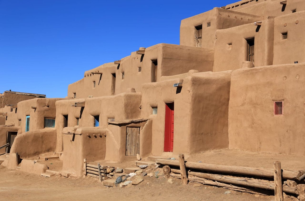
120 Veterans Highway, Taos, New Mexico 87571
Check for current hours here
Located just north of Taos (about a one-hour-and-forty-minute drive from Santa Fe), the history of this pueblo and its people extends as far back in time as 1,000 years, with many of the present buildings having likely been built somewhere between 1,000 and 1,450 A.D. It’s one of the Eight Northern Pueblos, a National Historic Landmark, and considered to be one of the oldest continuously inhabited communities in the United States.
When Spanish explorers first set eyes on the Pueblo in 1540, they thought they’d found one of the fabled golden cities of Cibola. And the setting is certainly just as glorious and inspiring, with the backdrop for the Pueblo being the dramatic Taos Mountains.
The tribal lands consist of about 95,000 acres, and there are about 4,500 people who are part of the Pueblo, though only about 150 people reside there full-time. It’s a very private community, and residents there rarely talk about their religion or their customs. Information in general is rather scant because the tribe’s language, Tanoan, has never been written down.
The Pueblo is arranged in two multi-story structures, the north house (hlauuma) and the south house (hlaukwima), both made almost entirely of adobe and which look much the same today as when they were first built hundreds of years ago. In 1970, President Richard Nixon signed off on the bill that returned Blue Lake—considered sacred land by the Pueblo—to the tribe. The lake and its 48,000 acres are off limits to all except members of the Pueblo.
Having lived off of their hunting for centuries, the tribe also excels in their arts and crafts work with animal skins—and are renowned for their moccasins, boots, and drums. But they’re also well respected as jewelers and potters. (Signs mark houses around the plaza that sell arts and crafts.) In addition, the tribe owns and operates the Taos Mountain Casino.
The Pueblo is open to visitors most of the year, but closes every early spring for eight weeks. Any sketching, painting, or commercial photography requires advance written approval; and photographs and recording are prohibited at religious ceremonies. The tribe’s annual San Geronimo Feast Day (September 30) is open to outsiders and serves as a trade fair. It also includes an annual foot race (in the morning) and an afternoon of being teased (by the tribe’s Koshare—tribal clowns).
1239 NM-53, Zuni, New Mexico 87327
Check for current hours here
Zuni Pueblo is the largest of the nineteen New Mexican Pueblos, covering more than 700 square miles and with a population of over 10,000. An artistically-oriented tribe, Zuni Pueblo considers itself the state’s most traditional of the pueblos, and views their members as an “artist’s colony”—their main industry being inlaid silverwork, stone “fetish” carving, and pottery.
It’s about a four-hour drive west of Santa Fe, just south of Gallup, and most of its residents live in the main village, with others residing in the nearby community of Blackrock. The Zuni people have been in the Southwest for thousands of years, surviving primarily as farmers. The pueblo has been in its current spot since at least 1300. The Zuni mark their year with a cycle of traditional ceremonial activities, the most widely known being their annual Sha’lak’o event, an early winter festival where dancers representing the couriers of the rain deities come to bless new homes.
Please be aware that there are restrictions in place for non-Zuni wishing to witness the Zuni’s religious activities. Visitors are asked to respect the tribe’s cultural privacy by following the appropriate etiquette and guidelines. To learn more about the Zuni, there’s the Zuni Visitor Center and the A:shiwi A:wan Museum and Heritage Center.
1120 Canyon Road, Santa Fe, New Mexico 87501
Check for current hours here
One of Santa Fe’s iconic buildings, and one of the more notable ones designed by the city’s preeminent Santa Fe architect John Gaw Meem. Built in 1940 (in commemoration of the 400th anniversary of Francisco Vasquez de Coronado’s exploration of the Southwest), fans claim it as the largest Spanish adobe structure in the United States. It was also built to serve as the permanent home to the hand-carved stone reredos (ornamental screens covering the wall at the back of an altar) that in 1761 had been carved for the Plaza’s Chapel of Our Lady of Light.
Still operational, the church was constructed much in the way that many Northern New Mexico churches were built: by its parishioners. In this case, parishioners mixed the more than 200,000 mud-and-straw adobe bricks and hauled them into place. In the end, it’s a structure that architecture critic Chris Wilson described as "the last, great adobe mission.”
631 Paseo De Peralta, Santa Fe, New Mexico 87501
Check for current hours here
Another downtown religious-historical treasure, and one to be enjoyed by anyone and everyone, this large white cross commands the top of Fort Marcy Park and affords visitors with perhaps the best view of the city and its surroundings (the Jemez and the Sangre de Cristo Mountains).
It was built in honor of 21 fallen Franciscan friars in the 1680 Pueblo Indian Revolt. (The Indians revolted, though, because of dire straits and poverty brought on by drought, slavery, and mistreatment by the Spanish colonialists; with the unfortunate consequence of the 21 friars being killed.)
Also, on the walk up, there are historical commemorative plaques (laid there by the city’s Historic Santa Fe Foundation) that chronicle the town’s 400-year-plus history.
There are also circular fireplaces on the walk up, each with remnants of charred coals. During the first week in September, when the city turns itself over to its Fiestas de Santa Fe, these outdoor firepits are turned into bonfires to light the way for those wanting to trek up to the Cross at night. The Fiestas was inaugurated in 1692 to celebrate the peaceful return of the Spanish. On the final night of Fiesta Week, Mass is celebrated at St. Francis Cathedral followed by a candlelight procession up to the Cross.
37 Co Rd 75, Truchas, New Mexico 87578
Check for current hours here
It may just seem like a little ol’ church to some, but, oh, what a church. It was built somewhere around 1805, about 50 years after the founding of the Northern New Mexico village, Truchas, that it serves. Nuestra Señora del Sagrado Rosario (Our Lady of the Rosary) is a shining example of the minimalist Spanish colonial style of the late 18th and early 19th centuries. Made of a sturdy adobe brick, this house of worship contains a treasure of santos, bultos, and other artifacts collected by generations of worshipers – notably the works fashioned by the state’s oldest santero, known as the “Truchas Master.” Two of the three known altar screen retablos created by him are located here.
Truchas itself, one of the villages along the High Road to Taos (about a 45 minute drive from Santa Fe), is worth a look, too. The 1,000 or so residents, many of whom come from families that go back to the village’s founding back in 1754, sits on the edge of a canyon high up in the Sangre de Cristo Mountains at 8,400 feet. Settled in 1754, the community prospered almost immediately.
Formed as part of a Spanish land grant that was issued to twelve families from Chimayo and Pueblo Quemado (now Cordova), the town’s mission back then was to serve as a hindrance to the Comanches, who often trekked through Truchas on their way to raids on Santa Fe and other communities along the Rio Grande valley.
It’s now home to some of those families’ descendants, as well as many artists, weavers, wood carvers, and galleries. The church also remains extant; during the warm summer months worshippers use it for mass and other services.
2405 NM 76, Chamisal, New Mexico 87521
Check for current hours here
Located in the Las Trampas Historic District, this National Historic Landmark is on the High Road to Taos, about an hour north of Santa Fe. Although the church is typically open for visitors only on the weekends, it’s still worth stopping by and walking around it and taking a stroll through the village of Las Trampas, which is like stepping back in time.
First settled by 12 Spanish families in 1751, the village essentially grew around the church, which is on the north side of the town’s central dirt-road plaza. By 1776, the population had increased to 63 families, and because of its cultural and economic isolation, the church, and the town, remained, and have remained, immune to change.
The San José de Gracia Church, then, looks much as it does when it was first built, and remains one of the most-original and best-preserved examples of Spanish Colonial architecture in New Mexico. The town’s plaza, too, feels much like it must have centuries ago.
15 Santuario Dr. Chimayo, New Mexico 87522
Check for current hours here
The drive north to here from Santa Fe, which takes a leisurely 30 minutes at the most, is almost as special as this 200-plus-year-old church. Once you turn off of State Highway 84 and onto the smaller 503, the way the light plays off the crenellated hills, along with the feeling that you’re on the moon, maybe, and far and away from urbanity or civilization, has an almost spiritual quality to it. It’s a feeling that prepares you well for the unexpectedly—and even more spiritual sensation—you get upon entering this humble shrine (now a National Historic Landmark).
Nestled into a valley on the outskirts of the tiny town of Chimayo, at the bottom of a hillside through which flows the Santa Cruz River, El Santuario now has a constantly busy parking lot—which accommodates the nearly 300,000 people who visit each year. Some of whom go there regularly to scoop up the “holy dirt” in the little anteroom to the side of the church, which people gather from a hole in the ground that’s inside an even smaller room (el pocito—the “little well”) off the anteroom itself.
It’s why, years ago, New Mexico’s state historian called the church “the most important pilgrimage center in the United States.” It’s also why, even though it’s clearly a Catholic church, El Santuario gets people of all denominations—and no denominations—throughout the year. Many of whom come here for the holy dirt, which is believed to have healing powers. It’s a special place, almost indescribably so.
Its specialness stems from various sources: the beauty of where it is, the appeal of the tiny church itself, the river behind the church, the hills surrounding it, and the legend of how it got to be so special. The story tells of a friar, seeing a strange light bursting from the hillside, dropped to his knees to find the source of this beatific light – discovering there in the sandy soil, a crucifix and a hot spring that predated the arrival of the Spaniards (and the Catholic missionaries) that was long sacred to the Tewa Indians there.
During Holy Week around Easter time, thousands of pilgrims walk to El Santuario from Santa Fe, and even further away, as a sign of their faith. This tradition began in 1945, when U.S. servicemen who’d survived the Bataan Death March started walking to El Santuario as a way to thank Santo Niño de Atocha for “delivering them from evil.” But being a death march survivor, or a Catholic, or a person of whatever faith is no prerequisite for appreciating this special place.
417 Agua Fria St. Santa Fe, New Mexico 87501
Check for current hours here
Located somewhat across from the Cowgirl restaurant and near Iconik Coffee Roasters, this “crown jewel of Santa Fe” is so entrenched in the City Different that it’s easy to take it for granted, forget that it’s there, or understand its religious and cultural significance. Santuario de Nuestra Señora de Guadalupe is a historic Catholic shrine, the oldest standing shrine in the U.S. and dedicated to Our Lady of Guadalupe, aka the Blessed Virgin Mary. It was built sometime in the late 1700s or early 1800s. No longer an active parish church, it is still used for periodic masses.
Today it’s largely an art and history museum, containing the Archdiocese of Santa Fe’s collection of New Mexican santos (carved images of the saints), Italian Renaissance paintings, and Mexican baroque paintings.
The Shrine itself consists of the historical chapel, the Santuario de Guadalupe; a new larger Church of Our Lady of Guadalupe; the El Cerro de Tepeyac (a walking path featuring six tile mosaics illustrating the apparitions of Our Lady of Guadalupe to Juan Diego); and the can’t-miss 12-foot statue of our Lady of Guadalupe, located in front of the Santuario de Guadalupe.
Situated near the end of the Camino Real and just off the banks of the Santa Fe River (about a mile from the Plaza), the Santuario de Guadalupe is an adobe structure built on a Latin cross floor plan, with three-foot-thick adobe walls, a flat roof supported by pine vigas, a dirt floor, and a three-tiered bell tower. The parish flourished until 1922 when a fire razed the church’s roof, collapsed the spire, and damaged the painted frescoes (the traditional New Mexican carved and painted altar screen, the reredo, survived). Restoration this time was made in the style of a California Mission with a new pitched roof, a bell tower, and a wooden floor. It was remodeled again the late 1970s. And even though there are stated visiting hours, don’t be surprised if it’s closed or no one’s there; something to keep in mind.
131 Cathedral Place, Santa Fe, New Mexico 87501
Check for current hours here
Visible from the downtown Plaza, the St. Francis Cathedral Basilica, more often referred to as Saint Francis Cathedral, is a Catholic landmark and the mother church of the Archdiocese of Santa Fe. Also, because the new cathedral was constructed in 1886 in the Romanesque Revival style (replacing the older adobe church that was destroyed in the 1680 Pueblo Revolt), it’s quite easily distinguishable from downtown’s adobe-style buildings. It’s the crowning achievement of Santa Fe’s first Archbishop, Jean Baptiste Lamy, who served as the model for Willa Cather’s 1927 novel, Death Comes for the Archbishop.
The only part of the original church is the small adobe chapel dedicated to Our Lady La Conquistadora. Brought from Spain in 1625, the statue is the oldest representation of the Virgin Mary in the United States. The Cathedral was elevated to a Basilica by Pope Benedict XVI in 2005. Basilica means a church of particular importance in Rome and abroad.
choosing where to live

417 E. Palace Avenue, Santa Fe, NM 87501
417 E. Palace Avenue, Santa Fe, NM 87501